
His research was one of two studies awarded the 2020 Graham Cogley Award for excellence in glaciological research
17 July 2020
5 min read
A painstaking examination of historical maps, photos and descriptions of glaciers in Norway has won a new scientist an international award.
Paul Weber, at the University of Portsmouth, spent ‘months and months’ digitising hundreds of glaciers from old maps drawn between 1882–1916 to give an accurate picture of change in glacier ice cover.
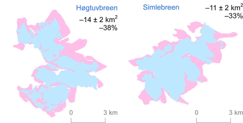
He found glaciers in Nordland, northern Norway, in 1899 covered about 1,712 square kilometres. By 2000, glaciers had retreated by 47 per cent, covering about 800 square kilometres.
His method of tracing glacial change might now serve as a blueprint for similar studies, which are useful for assessing the impact of global warming.
His research was one of two studies awarded the 2020 Graham Cogley Award for excellence in glaciological research by early career scientists.
This prestigious award is recognised by our entire research community and winning marks a highlight of my academic career so far. I'm very honoured to have been selected as a recipient.
Paul Weber, Phd student
Weber, 33, is currently finalising his PhD, based on his research.
He said: “This study found that since the end of the 19th century, substantial changes in the extent of Nordland’s glaciers have occurred, with loss of ice cover at a rate of about six per cent a decade. This demonstrates the value of historical maps for improving understanding of 20th century glacier change.
“This prestigious award is recognised by our entire research community and winning marks a highlight of my academic career so far. I'm very honoured to have been selected as a recipient.”
His study examined glaciers before the advent of aerial and satellite remote sensing, giving scientists the ability to look back in time and see the retreat of glaciers in one region over a period of 100 years.
His main focus was on finding out how accurate the old maps were, and as well as digitising maps, he used historical written descriptions and photographs taken during the original survey field trips to build a clear picture of the region’s glaciers a century ago.
He said: “It was months and months of painstaking work. The glaciers on the historical maps were of high quality but sometimes blurred the transition from glacier ice to the surrounding terrain surface. This meant that the modern methods I tested to identify the outlines of the glaciers automatically were of only limited use, and each digitised glacier still had to be manually adjusted.”
His study began in 2016 during a three-month Erasmus work placement at the Norwegian Water Resources and Energy Directorate in Oslo. He continued to work on the project during two other research placements in 2017 and in 2018, before writing up his findings in 2019.
His last two placements were co-funded by the University’s Faculty of Science placement scheme for postgraduate researchers. The University also paid the fees for publishing his work in the Journal of Glaciology.
Weber’s PhD supervisor, Dr Harold Lovell, senior lecturer in environmental systems at the University of Portsmouth, said he was delighted Paul’s research had won international acclaim.
He said: “Paul's paper was selected from approximately 70 student-authored papers so this is a truly excellent achievement.”
The Graham Cogley Award is sponsored by the International Glaciological Society (IGS) and the International Association of Cryospheric Sciences (IACS).
